To narrow your search results, enter the model number in the Search box above.
You can change the order of the results by clicking on a column header ("Model", "Year", etc.)

|
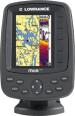
Elite-9x CHIRP |
Lowrance |
Marine GPS |
2015 |
|
Description: Marine GPS Type: Fishfinder - Screen Size: 9" - Screen Type: TFT LCD - Resolution: 800x480 - GPS Navigation Features: Built-In Antenna |
|
|
Elite-4 HDI Gold |
Lowrance |
Marine GPS |
2013 - 2015 |
|
Description: Marine GPS Type: Chartplotter, Fishfinder - Screen Size: 4.3" - Screen Type: TFT LCD - Resolution: 320x240 - Memory Format (MSD): Micro SD - GPS Navigation Features: Built-In Antenna - Transducer Frequency: 83/200 kHz |

|
Globalmap 5200C |
Lowrance |
Marine GPS |
2006 |
|
Description: Marine GPS Type: Chartplotter - Screen Size: 10.4" - Screen Type: LCD - Resolution: 480x480 - GPS Navigation Features: WAAS Receiver - Battery Type: DC Adaptor |

|
X86 DS |
Lowrance |
Marine GPS |
2006 |
|
Description: Marine GPS Type: Fishfinder, Sonor - Screen Size: 4.5" - Screen Type: LCD - Resolution: 240x240 - GPS Navigation Features: Thermometer, Language, Photo Viewer - Depth Range (Feet): 1000 - Transducer Type: Dual Frequency, Skimmer - Transducer Frequency: 83/200 kHz - Transducer Wattage: 1500 |

|
LMS-330C |
Lowrance |
Marine GPS |
2004 |
|
Description: Marine GPS Type: Chartplotter, Fishfinder, Sonor - Screen Type: TFT LCD - Resolution: 320x240, 640x480 - Memory: 256 MB - Memory Format (MSD): SD - GPS Navigation Features: Auto Zoom, Automatic Rerouting, Speed/Temp Sensor, Track Log, Language, Split Screen, Manual Zoom - Preloaded Map Coverage: Hawaii, United States, United States (Coastal), United States (Lakes/Rivers) - Depth Range (Feet): 900 - Transducer Type: Single Frequency, Skimmer - Transducer Frequency: 200 kHz - Transducer Wattage: 2400 - I/O Interfaces: NMEA - Battery Type: DC Adaptor |

|
X105C DF |
Lowrance |
Marine GPS |
2004 |
|
Description: Marine GPS Type: Fishfinder, Sonor - Screen Size: 5" - Screen Type: LCD - Resolution: 320x240 - Depth Range (Feet): 2500 - Transducer Type: Dual Frequency, Skimmer - Transducer Frequency: 50/200 kHz - Transducer Wattage: 4000 |

|
LCX-18C |
Lowrance |
Marine GPS |
2002 |
|
Description: Marine GPS Type: Chartplotter, Sonor - Resolution: 320x240, 640x480 - GPS Navigation Features: Track Log, Language - Preloaded Map Coverage: United States, United States (Lakes/Rivers) - Depth Range (Feet): 9800 - Transducer Type: Dual Frequency, Skimmer - Transducer Frequency: 50/200 kHz - Transducer Wattage: 8000 - Battery Type: DC Adaptor |

|
Airmap 500 |
Lowrance |
Handheld GPS |
2003 |
|
Description: Handheld Type: Aviation - Screen Type: LED - Resolution: 240x180 - Memory: 256 MB - Memory Format (MSD): SD - GPS Navigation Features: WAAS Receiver |

|
Globalmap 8200C |
Lowrance |
Marine GPS |
2010 |
|
Description: Marine GPS Type: Chartplotter - Screen Size: 8.4" - Screen Type: TFT LCD - Resolution: 240x240 - Memory Format (MSD): SD - GPS Navigation Features: WAAS Receiver - Preloaded Map Coverage: Hawaii, United States, United States (Lakes/Rivers) - Battery Type: DC Adaptor |

|
M68i S/Map |
Lowrance |
Marine GPS |
2003 |
|
Description: Marine GPS Type: Fishfinder, Sonor |

|
Globalmap 4900M |
Lowrance |
Marine GPS |
2005 |
|
Description: Marine GPS Type: Chartplotter - Screen Size: 8.4" - Screen Type: LCD - Resolution: 480x640 - Memory: 30 GB - Memory Format (MSD): Internal - GPS Navigation Features: WAAS Receiver, Split Screen, Language, Automatic Rerouting - # of Waypoints: 1000 - I/O Interfaces: RS-232 - Battery Type: DC Adaptor |
|
|
Elite-7 Ti |
Lowrance |
Marine GPS |
2016 |
|
Description: Marine GPS Type: Chartplotter, Fishfinder - Screen Size: 7" - Screen Type: TFT LCD - Resolution: 800x480 - Memory Format (MSD): Micro Drive - GPS Navigation Features: Built-In Antenna, Wireless, Touchscreen |
|
|
Elite-4x |
Lowrance |
Marine GPS |
2012 - 2014 |
|
Description: Marine GPS Type: Chartplotter, Fishfinder - Screen Size: 3.5" - Screen Type: TFT LCD - Resolution: 320x240 - Memory Format (MSD): Micro SD - GPS Navigation Features: Built-In Antenna - Depth Range (Feet): 1000 - Transducer Frequency: 83/200 kHz |
|
|
HDS-8 Gen2 |
Lowrance |
Marine GPS |
2012 |
|
Description: 83/200 kHz Transducer Model. Marine GPS Type: Chartplotter, Sonor - Screen Size: 8.4" - Screen Type: TFT LCD - Resolution: 600x800 - Memory Format (MSD): SD - GPS Navigation Features: Language - Transducer Frequency: 83/200 kHz - I/O Interfaces: NMEA, RJ-45 |

|
LMS-334C iGPS |
Lowrance |
Marine GPS |
2006 |
|
Description: Marine GPS Type: Chartplotter, Sonor - Screen Type: TFT LCD - Resolution: 480x480 - Memory: 2 GB - Memory Format (MSD): SD - GPS Navigation Features: WAAS Receiver, Language, Auto Zoom, Manual Zoom, Thermometer, Track Log - Preloaded Map Coverage: Hawaii, United States, United States (Coastal), United States (Lakes/Rivers) - Depth Range (Feet): 900 - Transducer Type: Dual Frequency, Skimmer - Transducer Frequency: 50/200 kHz - Transducer Wattage: 4000 - I/O Interfaces: RJ-45 - Battery Type: DC Adaptor |

|
HDS-10m |
Lowrance |
Marine GPS |
2009 |
|
Description: Marine GPS Type: Chartplotter - Screen Size: 10.4" - Screen Type: LED - Resolution: 600x800, 800x600 - Memory Format (MSD): SD - GPS Navigation Features: Language, Thermometer - Preloaded Map Coverage: United States, United States (Coastal) - # of Waypoints: 5000 - Transducer Type: Dual Frequency - Transducer Wattage: 250 - I/O Interfaces: NMEA |

|
iFinder Hunt |
Lowrance |
Handheld GPS |
2005 |
|
Description: Handheld Type: Outdoor - Screen Size: 3" - Screen Type: LED - Resolution: 240x180 - Memory: 2 GB - Memory Format (MSD): Micro SD - GPS Navigation Features: Compass, Barometer, Altimeter, Built-In Microphone - Battery Type: AA |

|
Globalmap 2400 |
Lowrance |
Marine GPS |
2010 |
|
Description: Marine GPS Type: Chartplotter - Screen Type: TFT LCD - Resolution: 240x240 - Battery Type: DC Adaptor |

|
Globalmap 1600 |
Lowrance |
Marine GPS |
2000 |
|
Description: Marine GPS Type: Chartplotter - Screen Type: TFT LCD - Resolution: 160x160 - GPS Navigation Features: Automatic Rerouting, Split Screen, Speed/Temp Sensor, Manual Zoom, Track Log, WAAS Receiver - Preloaded Map Coverage: Bahamas, Canada, Hawaii, Mexico, United States, United States (Coastal), United States (Lakes/Rivers) - # of Waypoints: 750 - Transducer Wattage: 3000 - Battery Type: Li-Ion |
|
|
Elite-4 DSI |
Lowrance |
Marine GPS |
2012 - 2014 |
|
Description: Marine GPS Type: Chartplotter, Fishfinder - Screen Size: 3.5" - Screen Type: TFT LCD - Resolution: 320x240 - Memory Format (MSD): Micro SD - GPS Navigation Features: Built-In Antenna - # of Waypoints: 3000 - Transducer Frequency: 455/800 kHz |

|
Endura Outback |
Lowrance |
Handheld GPS |
2009 |
|
Description: Handheld Type: Outdoor - Screen Size: 2.7" - Screen Type: TFT LCD - Resolution: 320x240 - Memory Format (MSD): Micro SD - GPS Navigation Features: Altimeter, Touchscreen, Photo Viewer - Preloaded Map Coverage: United States - I/O Interfaces: USB - Battery Type: AA |
|
|
HDS-9 Gen2 Touch |
Lowrance |
Marine GPS |
2012 |
|
Description: Marine GPS Type: Chartplotter, Fishfinder - Screen Size: 9" - Screen Type: TFT LCD - Resolution: 800x480 - Memory Format (MSD): SD - GPS Navigation Features: 2D/3D Mapping, Touchscreen |

|
Globalmap Baja 540C |
Lowrance |
GPS Navigation |
2004 |
|
Description: Screen Size: 5" - Resolution: 480x480 - Memory: 1 GB - Memory Format (MSD): SD - GPS Navigation Features: Automatic Rerouting, 2D/3D Mapping, Language - Battery Type: Li-Ion - I/O Interfaces: USB - Weight (oz): 24.0 |

|
Mark-5x DSI |
Lowrance |
Marine GPS |
2011 |
|
Description: Marine GPS Type: Fishfinder - Screen Size: 5" - Screen Type: TFT LCD - Resolution: 480x480 - GPS Navigation Features: Thermometer, Sonor Alarm, Depth Alarm, Automatic Rerouting - Depth Range (Feet): 250 - Transducer Type: Skimmer - Transducer Frequency: 455/800 kHz - Transducer Wattage: 4000 |

|
iWay 800C |
Lowrance |
GPS Navigation |
2007 |
|
Description: Screen Size: 10.4" - Resolution: 600x800 - Memory: 2 GB - Memory Format (MSD): Hard Disk - GPS Navigation Features: Traffic, 2D/3D Mapping, Touchscreen, Automatic Rerouting - I/O Interfaces: USB |
|
|
X125 |
Lowrance |
Marine GPS |
2003 |
|
Description: Marine GPS Type: Fishfinder, Sonor - Screen Size: 5" - Screen Type: LCD - Resolution: 480x480 - GPS Navigation Features: Language, Thermometer - Depth Range (Feet): 900 - Transducer Type: Skimmer - Transducer Frequency: 200 kHz - Transducer Wattage: 2400 - Battery Type: DC Adaptor |
|
M56i S/Map |
Lowrance |
Marine GPS |
2003 |
|
Description: Marine GPS Type: Fishfinder, Sonor |
|
|
Elite-4x DSI |
Lowrance |
Marine GPS |
2013 - 2015 |
|
Description: Marine GPS Type: Fishfinder - Screen Size: 4" - Screen Type: TFT LCD - Resolution: 320x240 - Transducer Frequency: 455/800 kHz |
|
|
Hook-5 |
Lowrance |
Marine GPS |
2016 |
|
Description: Marine GPS Type: Chartplotter, Fishfinder - Screen Size: 5" - Screen Type: TFT LCD - Resolution: 480x480 - GPS Navigation Features: Built-In Antenna - Preloaded Map Coverage: United States (Coastal), United States (Lakes/Rivers) |
|
|
Elite-5 |
Lowrance |
Marine GPS |
2010 |
|
Description: Marine GPS Type: Chartplotter, Fishfinder, Sonor - Screen Size: 5" - Screen Type: TFT LCD - Resolution: 480x480 - GPS Navigation Features: Thermometer - Preloaded Map Coverage: United States (Coastal), United States (Lakes/Rivers) - Depth Range (Feet): 1000 - # of Waypoints: 3000 - Transducer Type: Dual Frequency - Transducer Frequency: 83/200 kHz - Transducer Wattage: 500 |
|
|
X-55 |
Lowrance |
Marine GPS |
1992 |
|
Description: Marine GPS Type: Fishfinder - GPS Navigation Features: Thermometer, Fish Identifier - Battery Type: Battery Pack |
|
|
Elite-5 CHIRP |
Lowrance |
Marine GPS |
2014 |
|
Description: Marine GPS Type: Chartplotter, Fishfinder - Screen Size: 8" - Screen Type: TFT LCD - Resolution: 480x480 - Memory Format (MSD): Micro SD - Preloaded Map Coverage: Canada, United States, United States (Lakes/Rivers) |

|
HDS-5x |
Lowrance |
Marine GPS |
2009 |
|
Description: Marine GPS Type: Chartplotter - Screen Size: 5" - Screen Type: TFT LCD - Resolution: 480x480 - Memory Format (MSD): SD - GPS Navigation Features: Language, Thermometer, Automatic Rerouting - Depth Range (Feet): 5000 - # of Waypoints: 5000 - Transducer Type: Dual Frequency - Transducer Wattage: 250 |
|
|
HDS-12 Gen3 |
Lowrance |
Marine GPS |
2015 |
|
Description: Marine GPS Type: Chartplotter, Fishfinder - Screen Size: 12" - Screen Type: TFT LCD - Resolution: 1280x800 - Memory Format (MSD): SD, MMC |

|
X97 DF |
Lowrance |
Marine GPS |
2002 |
|
Description: Marine GPS Type: Fishfinder, Sonor - Screen Type: TFT LCD - GPS Navigation Features: Language - Transducer Type: Dual Frequency, Skimmer - Transducer Frequency: 50/200 kHz - Battery Type: DC Adaptor |
|
|
HDS-12 Gen3 |
Lowrance |
Marine GPS |
2015 |
|
Description: 83/200 kHz Transducer Model. Marine GPS Type: Chartplotter, Fishfinder - Screen Size: 12" - Screen Type: TFT LCD - Resolution: 1280x800 - Memory Format (MSD): SD, MMC - Transducer Frequency: 83/200 kHz |

|
iFinder PhD |
Lowrance |
Handheld GPS |
2004 |
|
Description: Handheld Type: Outdoor - Screen Size: 3" - Screen Type: LED - Resolution: 240x180 - Memory: 2 GB - Memory Format (MSD): Micro SD - GPS Navigation Features: Barometer, Compass, Altimeter, Built-In Microphone, MP3 Player - Battery Type: AA |
|
|
Elite-4m Gold |
Lowrance |
Marine GPS |
2013 - 2014 |
|
Description: Marine GPS Type: Chartplotter - Screen Size: 3.5" - Screen Type: TFT LCD - Resolution: 320x240 - Memory Format (MSD): Micro SD - GPS Navigation Features: Built-In Antenna - Preloaded Map Coverage: United States (Coastal), United States (Lakes/Rivers) - # of Waypoints: 3000 |

|
X51 |
Lowrance |
Marine GPS |
2002 |
|
Description: Marine GPS Type: Fishfinder, Sonor - Screen Size: 4" - Screen Type: LCD - Resolution: 240x160 |
|
|
HDS-5x Gen 2 |
Lowrance |
Marine GPS |
2012 - 2015 |
|
Description: Marine GPS Type: Chartplotter - Screen Size: 5" - Screen Type: TFT LCD - Resolution: 480x480 - Memory Format (MSD): SD - GPS Navigation Features: Automatic Rerouting, Language, Thermometer - Transducer Frequency: 50/83/200 kHz - I/O Interfaces: RJ-45 |
|
|
Trophy-5m Baja |
Lowrance |
GPS Navigation |
2016 |
|
Description: Screen Size: 5" - Resolution: 480x480 - GPS Navigation Features: External Antenna - Preloaded Map Coverage: United States |

|
LMS-480M |
Lowrance |
Marine GPS |
2003 |
|
Description: Marine GPS Type: Chartplotter, Fishfinder, Sonor - Screen Type: LCD - Resolution: 480x480 - GPS Navigation Features: Split Screen, Auto Zoom, Fish Identifier, WAAS Receiver, Manual Zoom - Preloaded Map Coverage: Hawaii, United States, United States (Lakes/Rivers) - Depth Range (Feet): 1000 - Transducer Type: Single Frequency, Skimmer - Transducer Frequency: 200 kHz - Transducer Wattage: 3000 |
|
|
Elite-4m HD Gold |
Lowrance |
Marine GPS |
2013 - 2015 |
|
Description: Marine GPS Type: Chartplotter - Screen Size: 4.3" - Screen Type: TFT LCD - Resolution: 320x240 - Memory Format (MSD): Micro SD - GPS Navigation Features: Built-In Antenna - Preloaded Map Coverage: Canada, United States (Coastal) |
|
|
Elite-5 HDI |
Lowrance |
Marine GPS |
2013 - 2015 |
|
Description: Marine GPS Type: Chartplotter, Fishfinder - Screen Size: 5" - Screen Type: TFT LCD - Resolution: 480x480 - Memory Format (MSD): Micro SD - Preloaded Map Coverage: Canada, United States - # of Waypoints: 3000 |
|
|
Hook-4 |
Lowrance |
Marine GPS |
2016 |
|
Description: Marine GPS Type: Chartplotter, Fishfinder - Screen Size: 4.3" - Screen Type: TFT LCD - Resolution: 480x272 - GPS Navigation Features: Built-In Antenna - Preloaded Map Coverage: United States (Coastal), United States (Lakes/Rivers) |
|
|
HDS-12 Gen2 Touch |
Lowrance |
Marine GPS |
2012 |
|
Description: 50/200 kHz Transducer Model. Marine GPS Type: Chartplotter, Fishfinder - Screen Size: 12" - Screen Type: TFT LCD - Resolution: 1280x800 - Memory Format (MSD): SD - GPS Navigation Features: 2D/3D Mapping, Touchscreen - Transducer Frequency: 50/200 kHz |

|
iWay 350C |
Lowrance |
GPS Navigation |
2006 |
|
Description: Screen Size: 3.5" - Resolution: 320x240 - Memory: 4 GB - Memory Format (MSD): Internal - GPS Navigation Features: Point of Interest, 2D/3D Mapping, FM Modulator, Traffic, Language, Automatic Rerouting, Voice Guidance - Battery Type: Li-Ion - I/O Interfaces: USB |

|
LCX-15 MT |
Lowrance |
Marine GPS |
2010 |
|
Description: Marine GPS Type: Chartplotter, Sonor - Screen Size: 6.5" - Screen Type: TFT LCD - Resolution: 350x480 - Memory: 512 MB - Memory Format (MSD): SD - GPS Navigation Features: Sonor Alarm, WAAS Receiver - Preloaded Map Coverage: United States - Depth Range (Feet): 9800 - # of Waypoints: 1000 - Transducer Type: Dual Frequency, Skimmer - Transducer Frequency: 50/200 kHz - Transducer Wattage: 8000 - I/O Interfaces: NMEA |

|
iWay 700C |
Lowrance |
GPS Navigation |
2007 |
|
Description: Screen Size: 7" - Resolution: 480x640 - Memory: 2 GB - Memory Format (MSD): Hard Disk - GPS Navigation Features: Traffic, Touchscreen, Automatic Rerouting, 2D/3D Mapping - I/O Interfaces: USB |

|
X107C DF |
Lowrance |
Marine GPS |
2004 |
|
Description: Marine GPS Type: Fishfinder, Sonor - Screen Size: 5" - Screen Type: LCD - Resolution: 480x480 - GPS Navigation Features: Language, Fish Identifier - Depth Range (Feet): 2500 - Transducer Type: Dual Frequency, Skimmer - Transducer Frequency: 50/200 kHz - Transducer Wattage: 4000 |

 Home
Home


 Car Stereo


